A
short rugged coastal walk along the scenic Iona Sand. Enjoy
stunning seascapes and views to Iona and Abbey and explore the
history of the Tormore Quarries.
Route
Details
No
car required - Distance 2 miles, 1 hour. Start and finish at
Seaview in Fionnphort Village. Good walking shoes required.
Leaving
from Seaview's white gate, cross the main road and walk down
the wee road opposite Seaview. At the bottom of the hill on
the left is Fionnphort Beach. On the right you will find the
old graveyard, now unused, has interesting granite steps outside
the boundary wall which were used for mounting your "trusty
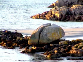
steed" in bygones times. Fionnphort's (white beach or port)
beach has white sands with a large split rock in the centre
of it. At low tide you can walk to "Fingal's Rock",
where legend has it that Fingal the giant (who stayed here on
his journey from Ireland to Staffa), woke up one day in a poor
temper, picked up the rock and threw it in the air and smashing
it onto the bed rock which caused it's present day split. From
the beach you can see a panorama of the Village, pier, Iona
and the Abbey.
Crossing
north from the beach climb onto the hillside passing the
"big rock" as you pick up a rough but well worn
path. Take time to look around and admire the increasingly
spectacular views of the pier, beach, Iona and Abbey.
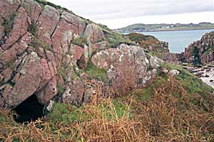
Near
to the Tormore pier and above the sandy cove, hidden amongst
the rocks is a cave called "The Cave of the Dead",
large enough in size to hold a coffin containing an ancient
Scot's king. The perfect place to shelter in bad weather
for the final journey of burial to Iona. The sandy cove
is an idyllic spot for a picnic and a wee snooze on a
sunny summer's day.
At
the partially ruined Tormore Quarry Pier you look across
"Bull Hole" to "Eilean nam Ban" (Island
of the Women) where it is said Columba banished women
from Iona because he thought they were troublesome! The
anchorage of Bull Hole to the north is a safe anchorage
for the Iona Ferry and local fishing boats in the area.
From the old pier follow the track uphill, eastwards and
into the quarry. This track had a tramway which carried
the quarried red granite down to the waiting boats at
the pier to be exported all over the world.
The
quarry contains the magnificent red granite which is unique
both in colour (almost pink) and also that large slabs
can be quarried without any flaws or cracks, and when
polished makes superb facing stone on buildings. There
is a sample of the polished granite on the gate pillar
at Seaview. This stone, which the Abbey and Seaview were
built of, was used all over the world.
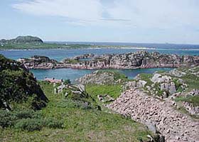
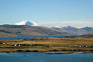
On top of the hill above the quarry you
have a spectacular panoramic view of Iona, Staffa, Erraid, The
Ross of Mull, Tiree, Coll, Jura, Islay, North Mull and the Burg
peninsular. After taking these breathtaking views proceed south
out of the quarry, down the hill, past Bruach Mhor, through
the gate turning right onto the main road. Fionnphort Village
is just a 5 minute walk.
Wildlife
Watch
All
year:
Seals, hooded crows, buzzards, ravens, otters, seabirds including
kittiwake, terns, shag and eider ducks
Summer: Dolphins
An
excursion to the tidal island lying just of the south west corner
of the Ross of Mull. It has historical connections with the
relatives of the famous writer Robert Louis Stevenson, who was
part of the "Stevenson lighthouse family."
Route
Details
OS
pathfinder 341 Iona and Bunessan 353 Torran rocks, South Mull
coast.A
car is required for the 5 minute drive from Seaview.
On
leaving Seaview travel east for 50 yards, then turn right
leaving the main road at the Knockvologan signpost. Follow
the road for 4 miles until you come to a closed gate.
Park you car in the painted boxes besides the sheds on
the left. Stout walking gear required. The crossing to
the island is tidal so your maximum time on the island
(at large tides) would be approximately on hour either
side of low tide. You can ask John for advice on current
conditions before setting off.
When
you leave your car, go through the gate, passing the fields
and farm steading on the right. Walk over the hill for a few
hundred yards to the end of the tar road. Looking south you
will find a distant, splendid, panoramic view of Jura with the
isolated, desolate "Torran Rocks" in the foreground.
Continue down the track to the silver strands of the Knockvologan
beaches stretching out to the east and west below the machair.
An ideal spot for a bit of unbathing! Turn right and follow
the beach west until you come to the sandy channel running north
- south between mainland Mull and Erraid. Follow the channel
on the Mull side to it's north end and cross over the wee stream
(at low tide) to the North East point of Erraid. A well defined
grassy track will take you west above the estuary and ½
mile further on,on a slope above the estuary you come to expertly
built granite houses, outhouses, pier and walled gardens. Constructed
superbly of the grey Erraid granite the houses served as the
landbase for the construction of "Dhu Heartach" lighthouse,
built by Thomas Stevenson (Robert Louis Stevenson's father)
and completed in 1874. The quarry for the grey granite lies
to the west above the houses. The absolute symmetry of the joints
and blocks of the buildings lay testament to the skill of the
stonemasons at the time of construction. The cottages became
the lighthouse keepers family homes.
Robert
Louis Stevenson spent part of his childhood on Erraid,
being a member of the great Stevenson Family, renowned
for lighthouse engineering. In Stevenson's "Kidnapped",
the hero, David Balfour is shipwrecked and comes ashore
on the south coast of Erraid at a sandy bay (known as
Balfour's Bay). In "Treasure Island" Jack Hawkins
chart bears a resemblance to Erraid.
On
the west side of the houses go through a gate and follow the
grassy path up the slope and through the quarry. The path then
forks. Take the left fork and the track rises quickly and steeply
to the top of a hillock. Perched here is the renovated, now
disused, signal station for the lighthouse. The views from here
are breathtaking. To the north and west you will see Iona, the
Abbey and the sound of Iona below. To the north east you see
The Ross of Mull with Benmore in the distance. To the south,
the "Torran Rocks". From here on a clear day you can
see the lighthouse some 12 miles to the south west, standing
126ft on an exposed reef 50ft high. Return to your car by the
way you came making sure you allowed enough time for the tides.
2 hours maximum time is recommended at big tides!
A
short walk across open moorland on the Ross of Mull to a narrow
bay, a bonnie quiet spot with historic cottages.
Route
Details
O.S map pathfinder 341 Iona and Bunessan. Car required.5
minutes drive from Seaview on the A849 travelling eastwards
towards Bunessan. Approximately 150 yards before the Esso garage
at Ardfenaig on the left hand side, there is a gate and track.
This is your starting point. Stout footware is recommended.
Approx. 3 miles, 2 hours.
On
leaving the road, cross the footbridge and go through
the gate and onto the track. Head northwards on the track
for approx ¼ mile. The track at first is hard with
small stones as a base however it eventually narrows and
becomes grassy. On either side of you are pleasant, rolling,grassy
fields of Ardfenaig. At the end of this stretch, go through
the gate.The track bears right across open moorland. The
track and moorland become wet and muddy in the winter
but generally dries out in the summer. After ½
mile the track trails to the right through hilly outcrops
and then a splendid wall (built in the "Galloway"
style) borders the path down to Camus Tuath.
The
old quarry workers houses overlooking the bay are now used as
an adventure centre for young people. The disused quarry is
on the opposite side of the bay and can be reached by walking
east along the shore and crossing at the head of the inlet then
walking down the other side of the lagoon. From the old quarry
above, the disused tramway leads down to a superb granite block
pier where the granite was exported to Tiree and therafter to
Skerryvore The granite here is not as pink as that of the Tormore
quarry, and also has a coarser texture. The granite was used
to build Skerryvore Lighthouse which sits out in the Atlantic
approx 30 miles west of The Ross of Mull, pounded by the severest
storms since 1844. The lighthouse was designed by Alan Stevenson
(one of the "Lighthouse Stevenson's") uncle of the
writer Robert Louis.
Camus
is a peaceful spot ideal for a picnic and on looking north
you see panoramic views of North Mull, Ulva, Little Colonsay.
If you are quiet on arrival you may see seals and otters
playing in the bay. You return home the same way as you
came. As you retrace your steps along the path on the
open moor approximately halfway along there is a large
open ditch running north. Follow the ditch crossing the
peat moor heading north for a few hundred yards.
This walking is rugged and wet with
no defined track, watch out for the peat bog! Ahead of
you is a hillock , follow the bottom of the hillock north
until you see a small burn and follow this down a gentle
slope until you see the short machair grass and two wonderful
sandy beaches ahead of you.
Traigh
na Margaidh (Market Bay) is one of a very few sand beaches on
the north coast of the Ross. However, it is one of the most
scenic and secluded sands on the Ross with magnificent views
to Staffa and North Mull. The Royal Family used to picnic here
and perhaps "skinny dip" when they were cruising the
western isles on the Royal Yacht Britannia. Return the way you
came to the track , turn right onto it, and trace your steps
back to the main road.
Wildlife
Watch
Eagles,
buzzards, kestrels, seals, otters, red deer, hen harrier, peregrine,
merlin, merganser and eider ducks.
A
day out exploring the southern cost of the Ross of Mull. Grand
clifftop views, remote beaches, and an abandoned highland township.
Route
Details
OS
Pathfinder 341,342 and 353 1:25,000 Car required. An all day
excursion, 9 miles in distance (including return). The starting
point lies 2 miles south of the village of Bunessan on the Ross
of Mull. From Seaview travel eastwards along the A849. On leaving
Bunessan take the sharp bend at the east end of the village
and drive up the hill. At the hills crest, turn right at the
sign for Assapol and Scoor. Travel along the tar road past Loch
Assapol. Open and go through the gate onto a reasonable dirt
track road. Follow the road up the hill and park at the side
of the road opposite Kilvickeon cemetery. This is lying in the
fields to the right (west) below you.
Kilvickeon
Cemetary & Beach
From
your car turn west off the main dirt track and walk down the
small track to the bottom of the 1st little slope. Turn right
through the gate, across the field to Kilvickeon church and
cemetary. This site can be seen all the way down from the car
park.
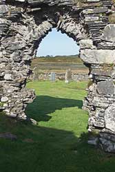
This
is the only medieval parish church on the Ross of Mull,
of which there are many worthwhile remains (OS grid reference:
412196). The entrance to the church is intact, although
the sandstone facings are not there leaving rough edges
of the arch. The door that originally fitted the arch
would be secured by a bar, the deep socket into which
the bar slid may be seen in the right hand wall as you
enter the church. To the left of the door a metre above
eye level, there is a projected piece of carved sandstone.
It is so weathered that it is impossible to know what
it represented. It is thought to have been a "sheela-na-gig",
a lewd or suggestive figure placed on the outer wall as
a mark of defiance.
A
similar carving on the outer wall of the nunnery on Iona is
described by the Royal Commissioners as "a female exhibitionist
figure". Above the carvin and just below the wall head
there are projecting thatch pegs for the ropes that tied down
the thatch against the gales of this western seaboard. There
is an early mid-sixteenth century grave slab on the south side
of the nave. Inside
the church there is a tombstone lying flat on the ground. Carved
on it you can just make out the shape of an early sword. Return
to the track and continuing down you come to a picturesque beach
divided by an island at low tide. A splendid spot for a family
picnic and swim or a winter beach-comb.
Scoor
& Shiaba
Return
to the main dirt track at the top of the hill and turn right
following the road to Scoor House, leaving your car at Kilvickeon
car park. Go left past the front of Scoor House through the
gate and follow the track through the fields to the gate at
the top of the field. On passing it, you climb to the top of
the ridge then turn left and follow the ridge towards the forest
across the valley. Soon you will spot the track to the deserted
township of Shiaba below you. Follow the rough path through
the moorland watching out for grouse and birds of prey as you
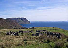
go. Soon you see the gable end of a building with other ruins
around it sitting on a fertile grassy mound above cliffs. Over
three hundred and fifty people lived here at the end of the
eighteenth century and the remains of their round-cornered houses
and boundary walls marking their croft lands can be seen.
The
Highland clearances came and the emigrant ships took people
away from the beaches below. Follow down past the houses
to the deer fence near the shore and follow it east back
up the hillside. Here you are likely to see deer, eagles
and wild goats. At one point you are fairly near the cliff
edge so please be careful of your footing! Continue onto
the high ground and look east across to the 1000ft cliffs
at Malcolm's Point with the Carsaig Arches just visible
at their foot. The scenery and atmosphere is so special
to this area that you are likely to stop often and gaze
in wonder at it all. The seascapes in the distant south
and east are that of the islands of Islay, Colonsay and
Jura.
Turning
inland return to the deer fence and follow it until you reach
a gap which brings you to higher moorland. Find the trig pillar
and climb to Cruachan Min. From here you can see a whole host
of islands. There is Islay, Jura, Scarba, Lunga, Luing, Mull,
Colonsay, Staffa, Coll, Tiree and Iona. Return home south and
west through the wide firebreak which has a gate at each end.
At the bottom of the firebreak is a shallow valley where there
was a battle between Mull men and the MacPhee's of Colonsay.
It is said the Mull men ambushed the MacPhee's and sent them
packing back home with their thumb's cut off to make it difficult
for them to row back home! Locate the Shiaba track at the other
side of the valley and the last mile back to Scoor House.
Wildlife
Watch
Red
deer, wild goats, buzzard, kestrel, golden eagles (along the
skyline) and seabirds on the cliffs. Woodland birds including
woodcock, wood pigeon, jackdaw and rooks. Moorland birds include
whinchats, skylark, wheatear and red grouse.
A
long walk below the dramatic Carsaig Cliffs taking in the spectacular
seaviews, cliffs and varying wildlife arriving at the natural
basalt arches of Malcolm's Point , another geological wonder
of Mull.
Route
Details
OS
pathfinder 342 map 1:25,000. A
long walk, 8 miles in distance including your return. You must
allow 3-5 hours. Carsaig lies on the south coast of Mull , 3
miles south east of Pennygael which is on the A849 midway between
Craignure and Fionnphort. From Seaview travel east along the
A849 towards Pennygael. Just before Pennygael there is a road
signposted Carsaig off to the right. Drive for about 1 mile
down to Carsaig Pier. Do not park on the pier, but park above
it taking care not to cause on obstruction. CAR REQUIRED.
Starting
from Carsaig Pier take the wooded track just above the
pier west, which follows along the head of the shore.
Looking south and eastwards are distant views of Jura,
Islay and Colonsay. On coming out of the trees on the
landward site is the picturesque bay of Carsaig with it's
amphitheatre of 700ft cliffs., standing guard over a small
fertile grassland. This spot is ideal for a peaceful picnic
on a sunny day. Continuing west , crossing over 2 burns
and follow the sometimes rough path at the head of the
basalt, lava sheeted shoreline. The cliffs on the landward
side will tower above you all the way to the Carsaig Arches.
On
the shore and Cliffside look our for the wild goats whom you
will probably smell before you see them. In sense you will probably
note a wide variety of nesting seabirds, golden eagles and ravens
which are commonly spotted.
After approximately 1 hours walking you will arrive at a break
in the cliffs, known as the "Nuns Pass", which can
give you access to the moorland on the clifftops. Below the
pass you will see the "Nuns Cave". Here nuns are suppose
to have hidden here after being chased out of Iona. Crosses
going back to 6th-9th centuries are carved on the walls. Also
a carved sailing ship dated 1633 is carved there. Sandstone
from the foreshore below the cave was quarried for restoration
work out of the Iona Abbey.
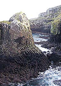
Continue
west on the path below the cliffs. Another hour further on the
path ends near the 1st of the 2 arches. Take care especially
in wet conditions! These are exposed parts, where the path runs
close to the sea. The arches are an impressive site, standing
out on the shore with a jagged skyline of 1000ft cliffs towering
above them. The arches, origionally seacaves, have been eroded
right through and eventually they will collapse to form sea
stacks. The large arch is 160ft from one end to the other. The
second arch is taller and slimmer. It also has a stack on top.
The arches consist of columnar basalts, not unlike those of
Staffa, if not quite as spectacular. Return by the same route
emphasizing great care should be taken, especially near the
arches.
Wildlife
Watch
Wild
goats, deer, seals, otters, eagles, ravens and buzzards. Numerous
varieties of seabirds including shag, cormorant, herring, black
backed gulls and kittiwakes. There is also black guillemot,
rock dove, rock pipit, wren, oystercatcher, curlew and redshank.
Only
2 miles south of Seaview, Tireragan an estate managed by a local
charity Highland Renewal is a wild and wonderful place with waymarked
walks to ruined villages, empty beaches and through amazing native
oak woodlands, whose regeneration is one of Highland Renewal's
main aims. Visit their website at www.highlandrenewal.org
or download a pdf version of one of theeir walk leaflets direct
buy clicking here.
OS
Explorer 373 Iona, Staffa and The Ross of Mull 1:25000
2 miles- about 2 hours
An
easy short coastal walk below and above basalt cliffs with interesting
geology and spectacular views. Ground tending to be wet and
slippy good waterproof walking boots required.
By
car head east from Bunessan village round the sharp bend and
turn off first left over the little bridge and follow left again
after it. A quarter mile further on you enter the Ardtun area
and to your left there are magnificient views north west over
Loch na Laitaich and Eilean na Liathanaich (grey island) with
its little lighthouse perched at one end. To the west Bunessan
pier used by the local shell fishermen and extremely important
to the areas economy. In the distance on a good day you can
pick out the pillar island Staffa to the north.
After
approximately one mile there is a turning off to the left
and you see a picturesque view of Eorabus, township, Ardtun,
nestled around Traigh Mor Bay
Follow the road to nearly the end and just before the
last 2 houses there is a gate facing north on the right
hand side of the road. Park your car and go through the
gate and follow the sheep track north through a field
and on to the open moor. In the mid distance there is
a little flat topped hill with a cairn on top(Dunan Mor).
Walk to the cairn and then carry on past it descending
north down to the fields above the shore.
Here
you pass through ruined croft houses and enclosures. On your
right above the notable columns of basalt cliffs become grander
as you walk north east. The sheep track takes to a steep gorge
with the sea funnelling into it. At this point you have to go
up onto the tops of the cliffs. Now follow across the headland
ahead of you in the distance is the magnificent mass of the
Ardmeanach Peninsular. After a short walk you will reach a shallow
open gully between the cliffs well above sea level and with
easy access. In the gully sides you will sea fossils of leaves
of oak ,hazel and plane trees. Return either by the same route
or follow along the top of the cliffs the whole way back to
the cairn.
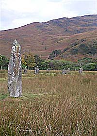
Access
to the bronze age circle is from Lochbuie Village road. As ou
travel towards Loch Buie, Ben Buie is sighted as are the trees
on the left, the road opens out to cross a stone bridge. Park
just at the bridge and go through the field towards a wood on
the right. You cross a plank of wood spanning a ditch. Near
here there is a single standing stone. The stone circle is behind
the rhododendrons to the left. Little is known about these stones
however it is a peaceful and beautiful spot.
OS
grid reference: 617251
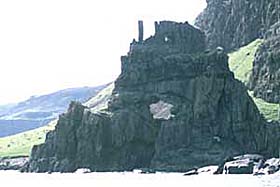
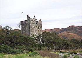
Moy
Castle
Standing
a short distance from the standing stones of Lochbuie, just
above the shoreline, near to a small burn at the head of Loch
Buie, this cstle was built in the 15th century by Hector MacLean,
brother of Maclean of Duart and the founder of the re-named
Maclaines of Lochbuie who made it their home. It is a 3 storey
tower with a garret. On the ground floor there is a well. It
was captured from the Maclaines and garrisoned by Campbell followers
but later returned to the Maclaines. It was abandoned in 1752
when a new house was built. The entrance door is locked now
because of a risk of crumbling masonry.
At
the end of the Lochbuie road follow the track eastwards, beside
Lochbuie shoreline, past the church and Lochbuie house.